Drone Scanning
Drone scanning, or drone-based aerial laser scanning (ALS), is an innovative remote sensing technology that leverages the capabilities of drones to perform high-resolution, three-dimensional mapping of landscapes and structures.

Drone scanning, or drone-based aerial laser scanning (ALS), is an innovative remote sensing technology that leverages the capabilities of drones to perform high-resolution, three-dimensional mapping of landscapes and structures.


© Florian Generotzky
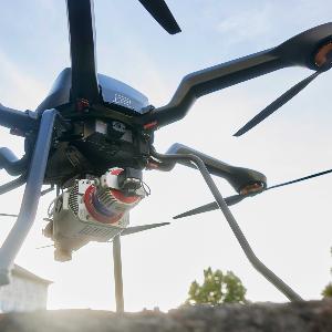
Drone scanning, or drone-based aerial laser scanning (ALS), is an innovative remote sensing technology that leverages the capabilities of drones to perform high-resolution, three-dimensional mapping of landscapes and structures. This method uses Light Detection and Ranging (LiDAR) sensors mounted on drones to capture detailed 3D representations of the terrain, even beneath dense vegetation. Drones offer significant advantages over traditional piloted aircraft, including greater flexibility, lower costs, and the ability to conduct rapid, opportunistic data collection in optimal environmental conditions.
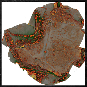
At the Institute, we utilize drone scanning to survey archaeological sites efficiently. Our AceCore Noa drone, equipped with a top-notch RIEGL ALS sensor, flies over target areas, capturing millions of data points per flight. These data points are then processed to generate detailed digital surface models (DSMs) and digital terrain models (DTMs). The flexibility of drone-based ALS allows us to conduct multiple flights over the same area, increasing data density and improving the resolution of the final models.
Drone scanning enables us to detect and analyze subtle archaeological features often hidden under vegetation, such as ancient cart tracks, quarries, and fortification walls. The high spatial resolution and accuracy of the data allow for precise mapping and interpretation of these features, which is crucial for our archaeological research and conservation efforts.

© Hades Project, IDCHS
Laser Scanning
Laser scanning, or terrestrial laser scanning (TLS), is a precise and efficient method for capturing detailed 3D models of surfaces and structures. This technique uses laser beams to measure distances to the surface of objects, creating a dense point cloud that accurately represents the scanned environment. Laser scanning is widely used in various fields, including archaeology, architecture, and engineering, for its ability to produce highly detailed and accurate 3D data.
At the Institute, we employ laser scanning to document and analyze archaeological sites with unparalleled detail. Our laser scanners capture millions of measurements per second, creating comprehensive 3D models of the landscape and structures. These models, with their comprehensive nature, allow us to visualize and study archaeological features in their precise spatial context, facilitating detailed analysis and interpretation.
Laser scanning is particularly beneficial for mapping complex and inaccessible areas. The high spatial-resolution data captured by our scanners enable us to detect minute details, such as tool marks on stone surfaces or subtle changes in terrain, which are crucial for our archaeological investigations. By integrating laser scanning data with other survey methods, we can create comprehensive and accurate digital reconstructions of archaeological sites, enhancing our understanding and preservation of cultural heritage